Avon moves forward with Main Street Mall proposal that would close Mikaela Way to vehicles
Upgrading the pedestrian area to promote connectivity has been on the town's docket for 25 years


Chris Dillmann/Vail Daily archive
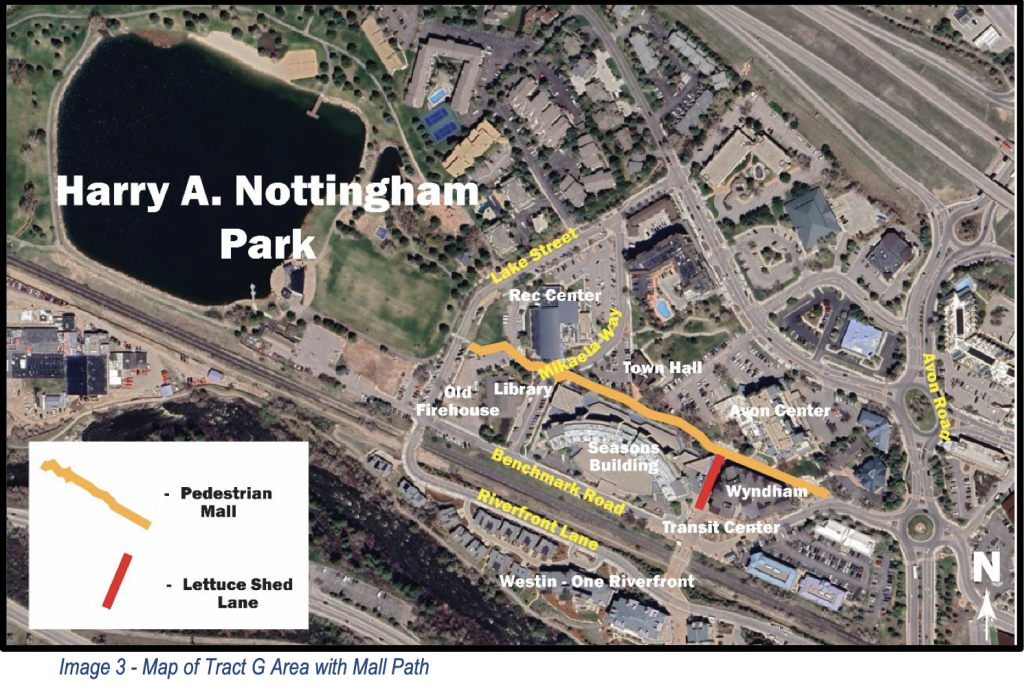
Avon’s Main Street Pedestrian Mall, which runs through the center of town from Avon Station to Harry A. Nottingham Park, has been slated for redevelopment for decades. The town plans to finally tackle the project this year with a goal to start construction in spring 2026.
History of Avon’s Main Street Pedestrian Mall
The Main Street Pedestrian Mall extends nearly a quarter mile from the northeast corner of the Wyndham Property to Lake Street by the east entrance to Harry A. Nottingham Park. It also encompasses Avon’s “civic campus,” which consists of the Avon Recreation Center, the Avon Public Library, the Avon Town Hall and the Avon Station transit center.
The pedestrian mall is older than the town of Avon. The section of land was dedicated to “park and municipal” use by the county in 1974. Town plans have pointed out the pedestrian mall as ineffective since 2000. The Avon Town Center Development Plan from 2000 called the pedestrian mall “unclear” and “awkward.”
The pedestrian mall was revisited in the West Town Center Investment Plan in 2007, and again in 2012 during the development of the Wyndham timeshare property. These last improvements to the mall occurred 13 years ago and were intended to be followed up on within a few years, according to Town Manager Eric Heil.
Most recently, new plans were drawn up for the pedestrian mall during the La Zona planning process that wrapped up in 2023, but no action was taken.
Support Local Journalism
Council picks option that promotes pedestrian safety, creates a new entrance to the park
On Tuesday, Avon Planner Max Morgan presented three options for the pedestrian mall redevelopment to the Town Council. The council selected the second option, citing increased connectedness to Harry A. Nottingham Park, pedestrian safety and cultivating a richer in-town experience.
The first option “represent(ed) the straightest path,” Morgan said. This option included a mini plaza between the Avon Recreation Center and the Avon Library, along with a parking reconfiguration and clear wayfinding.
The second option used the library as an existing boundary that would likely be unchanged despite anticipated development in the area. This plan incorporated the same mini plaza from the first option, as well as a path more aligned with the shape of the town. This option connects with Harry A. Nottingham Park at the south recreation trail, creating a variety of jumping-off points into different sections of town from there, including the soon-to-be-constructed restrooms and the Eagle Valley Trail.
Join the 17,000 readers who get the news from us daily.
Sign up for daily or weekly newsletters at VailDaily.com/newsletter
The second option assumes that the Old Fire Station at 351 Benchmark Rd. “likely isn’t going to get redeveloped and cause us to have to redo this space,” Morgan said. This differs from plans discussed by the council in October, when the space was considered for a future arts and culture center.
The third option would involve the smallest impact, but “leaves it incomplete for more work to be done at a future time,” Heil said. While the town would put in pavers along the existing path to help with wayfinding and do some landscaping, this option would be the least expensive and permit the greatest amount of future redevelopment.
Brian Sipes, a member of the Planning and Zoning Commission, spoke for the entire committee when he said that option two “is the preferred option by far … It puts people first, it doesn’t have any vehicular crossings, and the planning commission spent a lot of time talking about it as an experience.”
The second option, Sipes said, delivers people to the edge of the park by the future bathrooms, which can also serve as a security checkpoint during large town events like Salute to the U.S.A.
“Planning commission thinks it’s the only option that is good for people in the town,” Sipes said.
Heil’s recommendation was also option two.

“It does reduce the development area of the Old Fire Station, but as I look at the budget and we have no idea what we would do, I think that is so speculative …i t’s probably decades down the road, and in my opinion, it should not hold up doing the best pedestrian mall layout,” Heil said.
“I think the only option is option two,” said Lindsay Hardy, council member.
Hardy said that when she was a member of the Planning and Zoning Commission, “I asked why (the pedestrian mall) wasn’t being connected to the park, and it was said that Town Council would do that next,” Hardy said. “13 years later, here we are. My comment is, let’s do it right the first time … and I think option two is absolutely doing it right … It’s a better experience. It’s the route I already take when I’m trying to get around the lake, so it makes the most sense. It adds parking. It has that edge detail next to the library.”
Potential closure of Mikaela Way to vehicles
The council looked favorably upon the closure of Mikaela Way to vehicles in option two.
Mikaela Way moves through the library, recreation center and a daycare.
“It has been a recommendation from several consulting groups dating back almost 10 years that this close,” Morgan said.
If Mikaela Way were closed to vehicles, the roadway would be turned into an “enhanced crossing,” open to pedestrians, Morgan said.
Closing Mikaela Way to vehicular traffic “represents a solution to a lot of challenges,” Morgan said.
Morgan named benefits to the closure, including enhanced pedestrian safety, ADA compliance and supporting the town’s limited mobility population, as well as allowing the footprint for the potential parking garage by the recreation center to grow by at least 25%.
The closure would be reversible, and the town could reopen the road to vehicles as needed at high traffic times, or if the enhanced crossing was deemed unhelpful.
Following the council’s direction on Tuesday, the pedestrian mall plans will enter the design phase. The design plans will be seen by the Planning and Zoning Commission in July or August and then circulate through the other citizen committees before coming back to the council, likely in September, with a goal to start construction in spring 2026. Heil said he hoped to have cost estimates at that point to allow the town to budget for the project and submit grant applications for funding.


